
Freeze-Thaw Uncertainty Assessment
Project Summary:
The freeze-thaw (FT) state parameter derived from satellite microwave remote sensing quantifies the predominant frozen or non-frozen state of the landscape and is closely linked to surface energy budget and hydrologic activity, seasonal dynamics of vegetation growth, terrestrial carbon budgets and land-atmosphere trace gas exchange. Satellite microwave remote sensing is well suited for global FT monitoring due to its relative insensitivity to atmospheric contamination, its independence from solar illumination, and strong sensitivity to changes in landscape dielectric properties between frozen and thawed conditions. This study involves validation and uncertainty assessment of the global Freeze-thaw Earth System Data Record (FT-ESDR), derived from similar calibrated and overlapping satellite microwave sensor observations extending over more than 35 years of record. The FT-ESDR is one of the longest satellite environmental data records and enables improved quantification, diagnosis and attribution of global environmental trends and impacts.
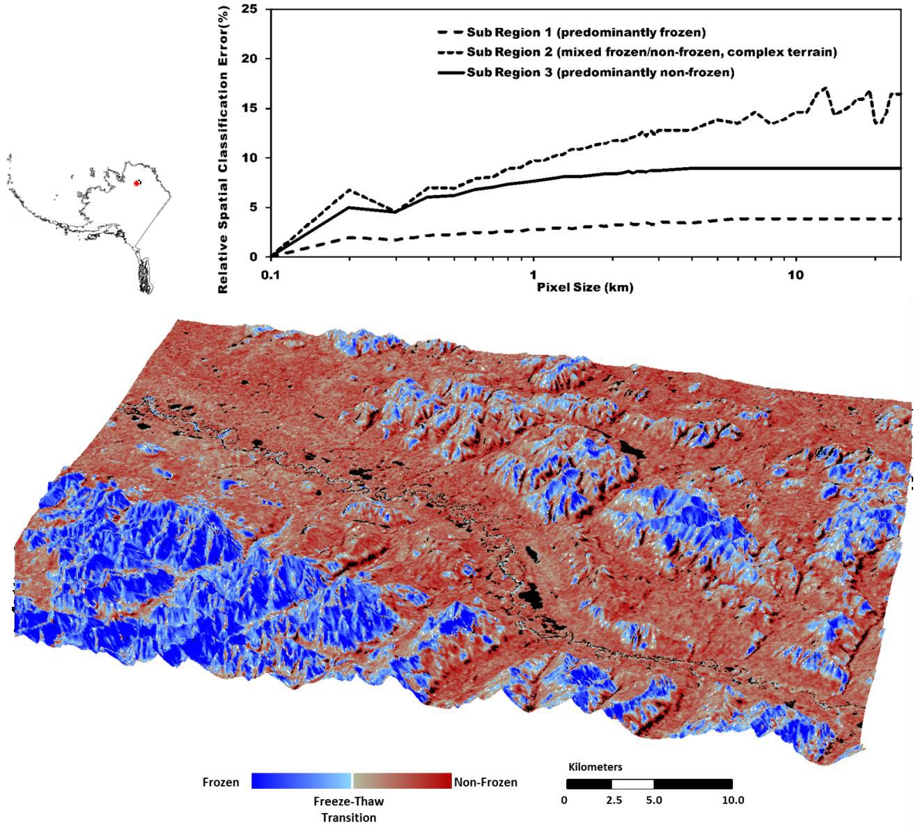
Figure: Spring thaw pattern over an Alaska sub-region defined from a landscape
freeze-thaw (FT) classification of 100m resolution satellite radar (PALSAR L-band)
backscatter (Du et al. 2014); the resulting image is draped over a DEM. Relative
change in apparent FT classification accuracy vs sensor footprint size is also shown
for three AK sub-regions at different points in the seasonal progression and with
varying terrain complexity.
Scientists
John Kimball (PI)
Jinyang Du
Youngwook Kim
Yonghong Yi
Kyle McDonald
Funding Agency
National Aeronautics and Space Administration
Publications
Colliander, A., K. McDonald, R. Zimmermann, R. Schroeder, J. Kimball, and E. Njoku, 2012.
Application of QuikSCAT backscatter to SMAP validation planning: Freeze/thaw over ALECTRA sites in Alaska from 2000 to 2007. IEEE Transactions on Geoscience and Remote Sensing 50(2), 461-468. pdf
Du, J., J.S. Kimball, M. Azarderakhsh, R.S. Dunbar, M. Moghaddam, and K.C. McDonald, 2014.
Classification of Alaska spring thaw characteristics using satellite L-band Radar remote sensing. IEEE Transactions on Geoscience and Remote Sensing 53 (1), 542-556.pdf
Kim, Y., J.S. Kimball, D.A. Robinson, and C. Derksen, 2015.
New satellite climate data records indicate strong coupling between recent frozen season changes and snow cover over high northern latitudes. Environmental Research Letters.
Kim, Y., J.S. Kimball, K. Didan, and G.M. Henebry, 2014.
Response of vegetation growth and productivity to spring climate indicators in the conterminous United States derived from satellite remote sensing data fusion. Agricultural and Forest Meteorology, 194, 132-143.pdf
Kim, Y., J.S. Kimball, K. Zhang, K. Didan, I. Velicogna, and K.C. McDonald, 2014.
Attribution of divergent northern vegetation growth responses to lengthening non-frozen seasons using satellite optical-NIR and microwave remote sensing. International Journal of Remote Sensing 35, 10, 3700-3721. pdf
Kim, Y., J.S. Kimball, K. Zhang, and K.C. McDonald, 2012.
Satellite detection of increasing northern hemisphere non-frozen seasons from 1979 to 2008: Implications for regional vegetation growth. Remote Sensing of Environment 121, 472-487.pdf
Podest, E., K.C. McDonald, and J.S. Kimball, 2014.
Multi-sensor microwave sensitivity to freeze-thaw dynamics across a complex boreal landscape. IEEE Transactions on Geoscience and Remote Sensing 52 (11), 6818-6828.View
Zhang, K., J.S. Kimball, Y. Kim, and K.C. McDonald, 2011.
Changing freeze-thaw seasons in northern high latitudes and associated influences on evapotranspiration. Hydrological Processes 25, 4142-4151.pdf
Links
FT-ESDR project
FT-ESDR data archives at NSIDC
NASA Soil Moisture Active Passive (SMAP) mission
NASA MEaSUREs program