
Remote Sensing of Land Water Mobility
Satellite remote sensing land atmosphere water and energy exchange.
Project Summary:
The lack of available water constrains hydrologic and ecological processes for two-thirds of the Earth’s land surface. We are working with colleagues at the NASA Jet Propulsion Laboratory to develop new satellite microwave remote sensing algorithms for detecting and monitoring land-atmosphere water and energy exchange over North America. These data will provide continuous weekly-annual observations of surface evaporation and vegetation conditions from 1988 onward that can be used for a variety of applications including monitoring agricultural, rangeland and forest health, improving regional weather forecasts and water resource monitoring. Regional and global data sets developed from this project include satellite based evapotranspiration (ET), terrestrial freeze-thaw status and net primary productivity (NPP).
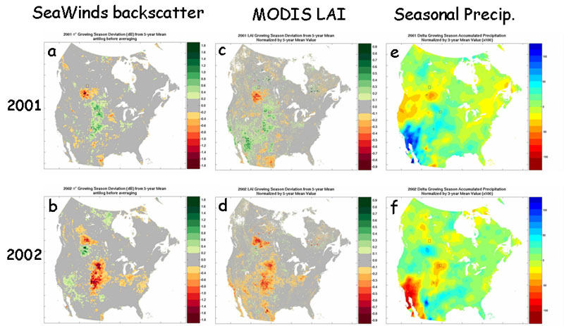
The map above shows Satellite observations of 2001-2002 drought effects on vegetation productivity across the central plains of North America from MODIS and SeaWinds; plates (a) and (b) show SeaWinds 2001 and 2002 growing season backscatter anomalies relative to the 5-year (2000-2004) mean; plates (c) and (d) show MODIS 2001 and 2002 growing season LAI anomalies relative the 5-year mean; plates (e) and (f) show corresponding 2001-02 precipitation anomalies (ERA-40, Nov.-Aug.) relative to the 3-year mean. Grassland productivity across the central US indicated by MODIS LAI measurements is found to be strongly correlated and inversely proportional to annual precipitation. Radar Ku-band backscatter observations from SeaWinds are also directly sensitive to vegetation structure and surface wetness associated with the regional drought response. The synergism between these products provides a more comprehensive measure of water and carbon cycle interactions and biosphere drought response that is sensitive to vegetation structure, photosynthetic leaf area and surface moisture, and provides potential daily global monitoring independent of solar illumination and cloud cover.