
Projects and Data
NASA Earth Missions
 VIIRS - The Visible Infrared Imaging Radiometer Suite (VIIRS) sensor aboard the NASA/NOAA Suomi NPP (SNP) and NOAA-20 (JPS) satellites are collecting multispectral visible and infrared global Earth imagery. VIIRS provides for continuity in Earth observations originally collected from the NASA EOS MODIS sensors and provides continuous, well-calibrated global environmental data records spanning multiple decades.
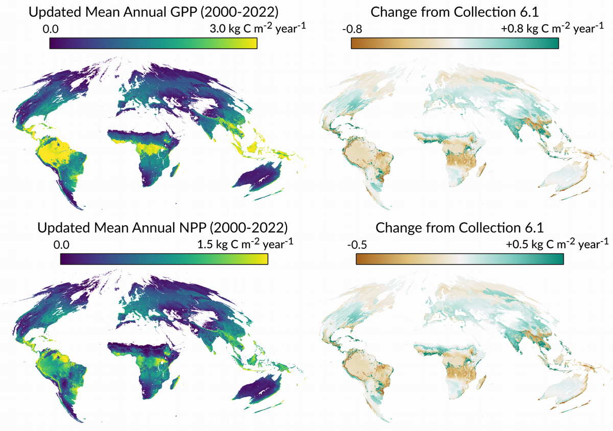
MODIS - The MODIS (Moderate Resolution Imaging Spectroradiometer) sensors on the NASA Earth Observing System (EOS) Terra and Aqua satellites have been operational since 2000 and 2002. NTSG developed algorithms and science data products for the MODIS vegetation productivity (MOD17) and ET (MOD16) operational products. The MODIS data products are a core component of Earth science research and global environmental monitoring capabilities.
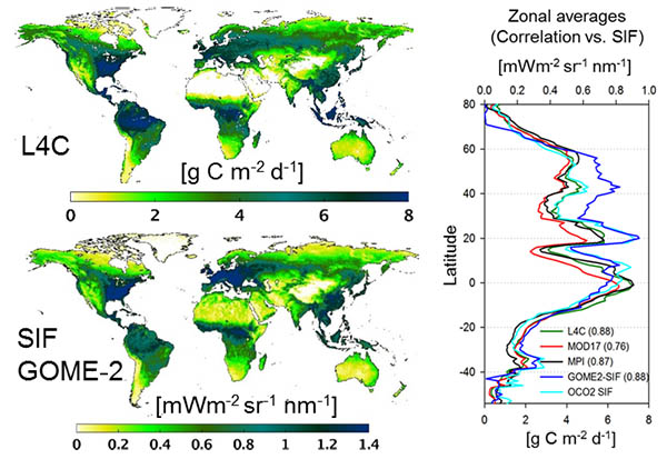 SMAP - The NASA Soil Moisture Active Passive (SMAP) mission was successfully launched in January 2015 and provides global L-band microwave observations of soil moisture and landscape freeze-thaw dynamics. NTSG developed science algorithms for the SMAP Level 4 Carbon (L4C) product, which provides global operational monitoring of ecosytem productivity and underlying environmental controls.
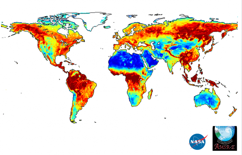 AMSR - The AMSR-E (Advanced Microwave Scanning Radiometer for EOS) sensor and follow-on JAXA AMSR2 sensor records provide multi-frequency microwave brightness temperature observations extending from 2002 to present. NTSG developed a global land parameter data record (LPDR) from calibrated AMSR observations, including daily surface air temperature, soil moisture, vegetation optical depth, atmosphere precipitable water vapor, surface water inundation dynamics and land surface freeze-thaw status. The LPDR is publicly available and supports a wide range of hydrological and ecological studies.
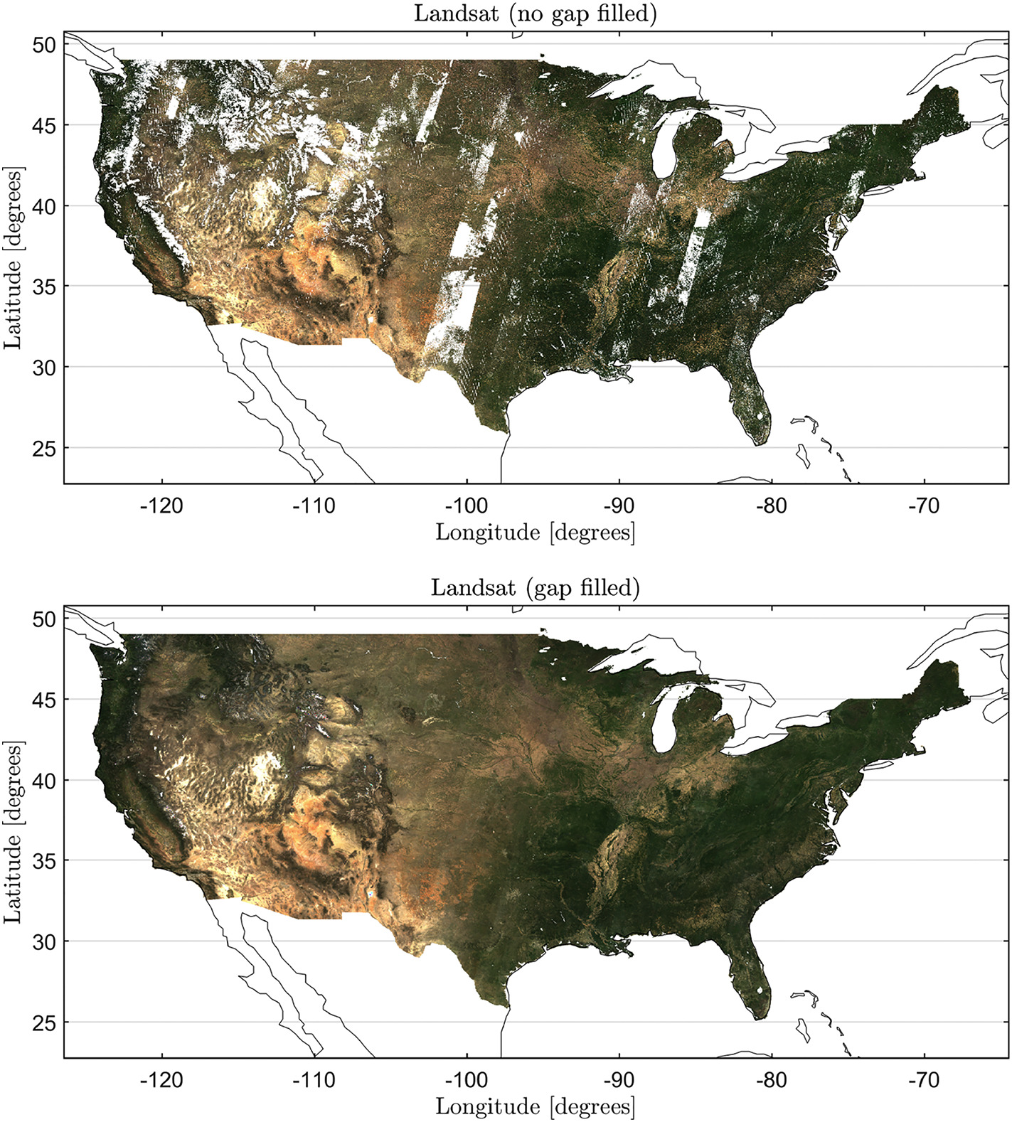 Landsat - The Landsat satellites provide the longest continuous Earth observation record, including landscape (30-m resolution) assessments of vegetation conditions and changes extending over multiple decades (since 1978). The Landsat NDVI (Normalized Difference Vegetation Index) is sensitive to variations in vegetation greenness and is widely used in ecology, forestry, agriculture, wildlife and other applications. We developed an NDVI climatology for the continental USA by exploiting best quality observations from the historical Landsat record. The Landsat NDVI record is publicly distributed through an online interactive decision support system (DSS) supported by Google Earth Engine.
Rangeland and Wildlife
Rangeland and Wildlife - The Sage Grouse Initiative is an USDA Natural Resources Conservation Service funded effort tovoluntarily reduce threats facing sage-grouse and rangelands on private lands. SGI has matured into acatalyst for rangeland and wildlife conservation across the North American west, focusing on the sharedvision of conservation through sustainable working landscapes and providing win-win solutions forproducers; sage-grouse and other wildlife species; and rangelands as a whole. SGI science partnersdevelop and utilize geospatial products to target, assess, and monitor conservation outcomes.
Hydrology
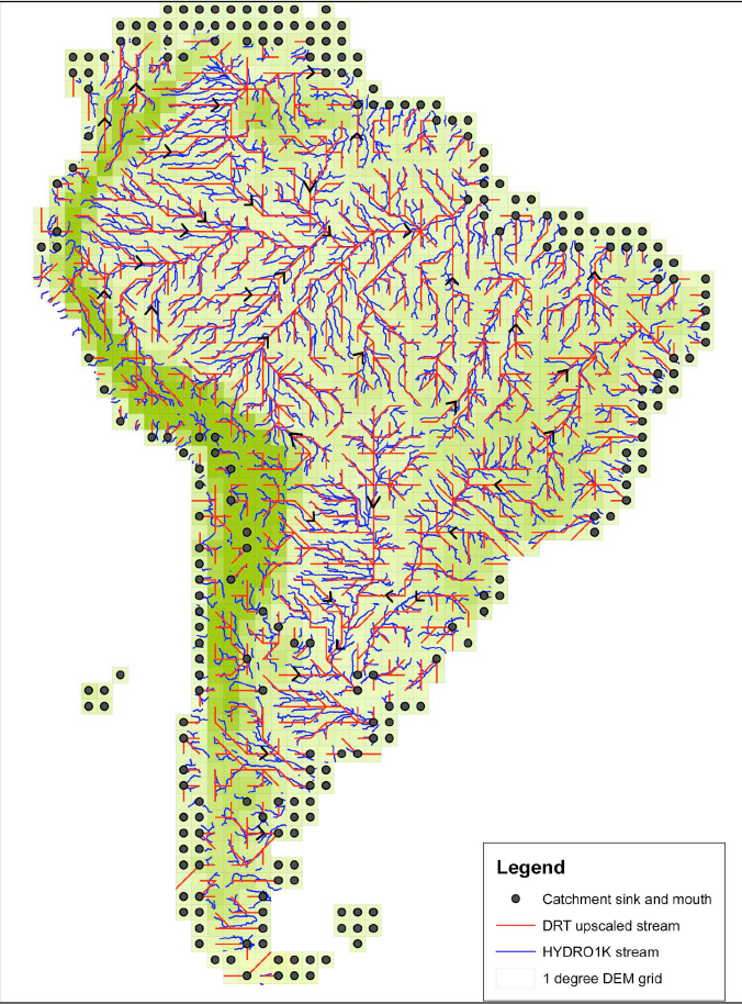 Dominant River Tracing (DRT) - We developed a hierarchical Dominant River Tracing (DRT) algorithm for automated extraction and spatial upscaling of basin flow directions and river networks using fine scale hydrography inputs (e.g. flow direction, river networks and flow accumulation). In contrast with previous upscaling methods, the DRT algorithm utilizes information on global and local drainage patterns from baseline fine scale hydrography to determine upscaled flow directions and other critical variables including upscaled basin area, basin shape and river lengths.
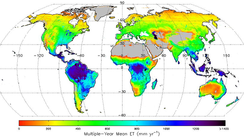 Global ET - The objective of this study was to generate a global long-term (1983-2013) daily ET record with well quantified accuracy for studies on regional/global water balances changes. We applied a satellite remote sensing based evapotranspiration (ET) algorithm to assess global terrestrial ET. The algorithm quantifies canopy transpiration and soil evaporation using a modified Penman-Monteith approach with biome-specific canopy conductance determined from the NDVI, and quantifies open water evaporation using a Priestley-Taylor approach.
![]() Lake Ice Phenology - We developed a satellite based Northern Hemisphere lake ice phenology data record using a temporal classification of AMSR (Advanced Microwave Scanning Radiometer) brightness temperature observations. The resulting geospatial lake ice record provides relatively precise mapping of daily ice cover variations for more than 900 lakes (76,671 lake pixels).
Lake Ice Phenology - We developed a satellite based Northern Hemisphere lake ice phenology data record using a temporal classification of AMSR (Advanced Microwave Scanning Radiometer) brightness temperature observations. The resulting geospatial lake ice record provides relatively precise mapping of daily ice cover variations for more than 900 lakes (76,671 lake pixels).
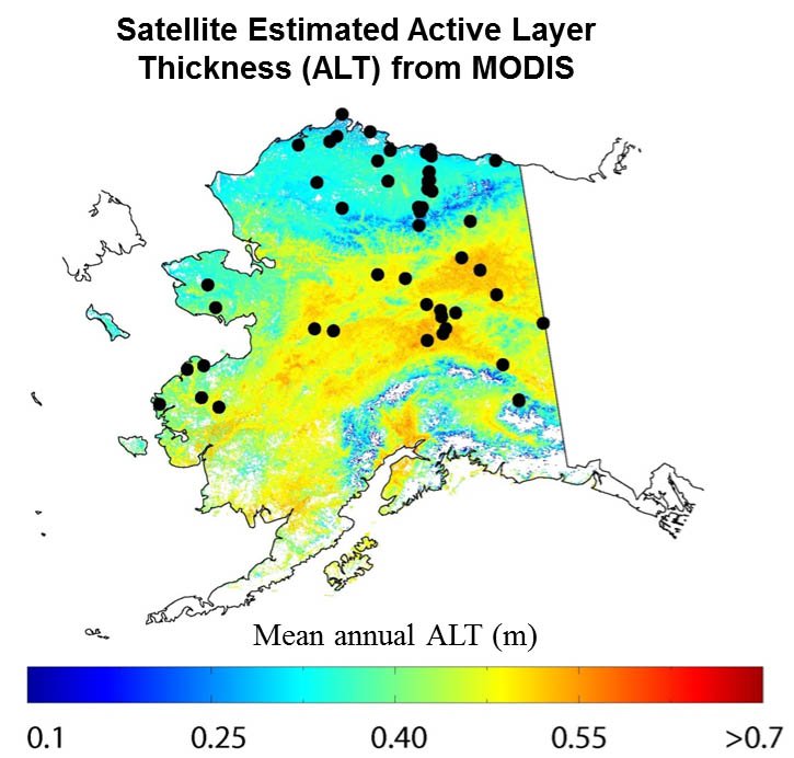 NASA Interdisciplinary Science (IDS) – Mapping Alaska permafrost processes and their impact on regional carbon fluxes. In this study we developed a satellite data driven approach for mapping and monitoring recent changes in permafrost active layer depth across Alaska. The soil process model used for this study was informed by low-frequency (L+P-band) synthetic aperture radar (SAR) retrievals from NASA AirMOSS and UAVSAR airborne radar sensors.
Measures: Freeze/Thaw ESDR & Wetlands ESDR - We developed and maintain a set of global Earth System Data Records (ESDRs) from calibrated multi-sensor satellite microwave remote sensing records. The Freeze/Thaw ESDR extends over more than 40 years and is one of the longest satellite environmental data records. The FT-ESDR classifies the daily frozen or non-frozen status of the landscape for all global land areas where frozen temperatures are a significant constraint to surface water mobility and ecosystem processes. The ESDR data support a range of hydrological and ecological studies and are publicly available through both NTSG and NASA data distribution facilities at the National Snow and Ice Data Center (NSIDC) and Alaska SAR Facility. These projects are part of the NASA MEaSUREs (Making Earth System data records for Use in Research Environments) program.
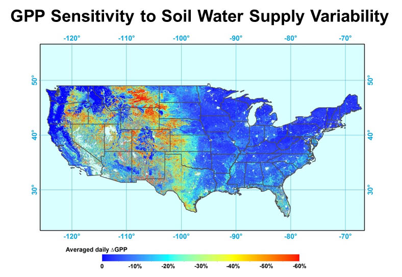 NASA Terrestrial Hydrology - Documenting Soil Moisture and Frozen Season Constraints to Vegetation Productivity
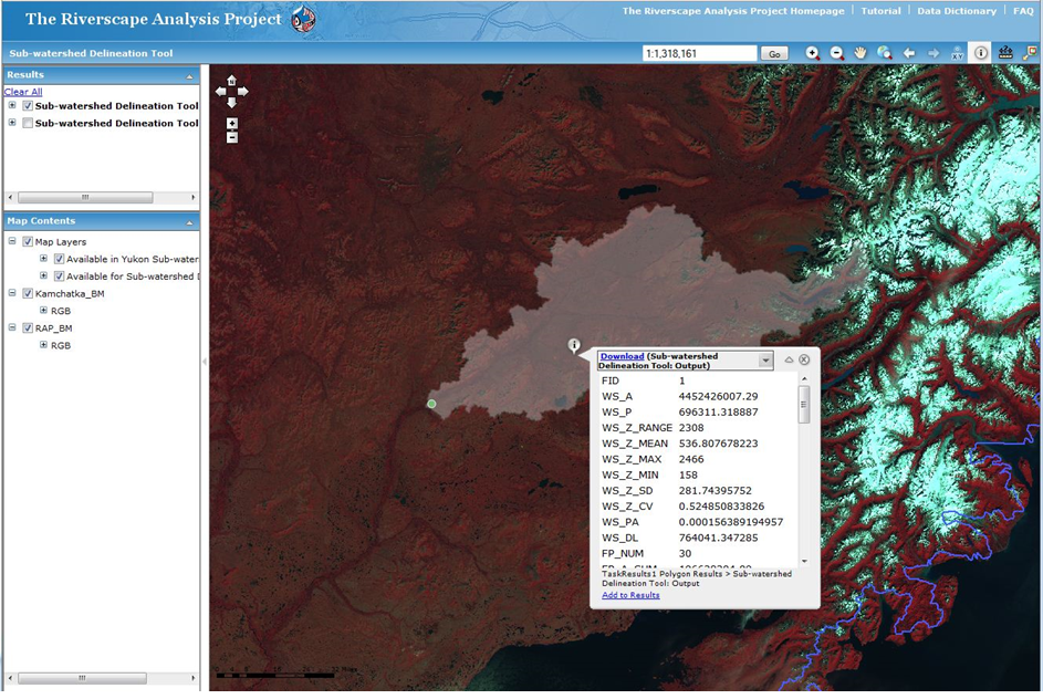 Riverscape Analysis Project (RAP) – RAP is a web-based GIS Decision Support System developed to inform wild salmon conservation efforts across the North Pacific Rim (NPR), based upon a consistent and robust classification (typology) of rivers and their freshwater physical habitats. RAP provides quantitative spatial metrics on habitat extent and quality for more than 1000 river systems, and has been used identify and evaluate critical habitat areas and their vulnerability for the major salmonid species. This project was funded by the Gordon and Betty Moore Foundation and NASA.
SmallSat Data Analysis - We are using meter and sub-meter scale imagery to measure non-binary ice conditions for rivers and lakes in selected catchments spanning regional environmental gradients. We are also employing consecutive acquisitions from the PlanetScope constellation, SkySat stereo image pairs and motion video for estimating river/lake surface height changes, river flow velocity and river discharge
Ecosystems
![]() NASA Arctic Boreal Vulnerability Experiment (ABoVE) - This NASA led field campaign extends across Alaska and NW Canada, with primary objectives to better understand the vulnerability and resilience of Arctic and boreal ecosystems, including impacts on local communities. Our role in the ABoVE involves improving regional predictions and understanding of landscape environmental controls on the Arctic-Boreal carbon budget for both CO2 and CH4.
NASA Arctic Boreal Vulnerability Experiment (ABoVE) - This NASA led field campaign extends across Alaska and NW Canada, with primary objectives to better understand the vulnerability and resilience of Arctic and boreal ecosystems, including impacts on local communities. Our role in the ABoVE involves improving regional predictions and understanding of landscape environmental controls on the Arctic-Boreal carbon budget for both CO2 and CH4.
![]() Biome-BGC - Biome-BGC is an ecosystem process model that estimates storage and flux of carbon, nitrogen and water. Biome-BGC is a computer program that estimates fluxes and storage of energy, water, carbon, and nitrogen for the vegetation and soil components of terrestrial ecosystems.
Biome-BGC - Biome-BGC is an ecosystem process model that estimates storage and flux of carbon, nitrogen and water. Biome-BGC is a computer program that estimates fluxes and storage of energy, water, carbon, and nitrogen for the vegetation and soil components of terrestrial ecosystems.
 North American Carbon Program (NACP) - Approximately 68-80 percent of the North American region experiences seasonal freezing and thawing with the relative influence of these processes on terrestrial carbon budgets generally increasing at higher latitudes and elevations. The timing and duration of surface and soil freeze-thaw state is closely linked to vegetation phenology and growing season dynamics in northern temperate, sub-alpine, boreal and arctic biomes.
![]() Phenology Assessment Using Satellite Radar & Microwave Remote Sensing - Seasonal vegetation dynamics significantly impact the carbon cycle and weather (surface energy balance, transpiration vapor fluxes). These impacts are related to growing season length for evergreen ecosystems, to timing of leaf flush and senescence for drought- or cold-deciduous systems, and to seasonal and annual variability in canopy biomass. Spaceborne remote sensing is the only practical tool for monitoring seasonal vegetation dynamics globally with high temporal repeat and moderate spatial resolution.
Phenology Assessment Using Satellite Radar & Microwave Remote Sensing - Seasonal vegetation dynamics significantly impact the carbon cycle and weather (surface energy balance, transpiration vapor fluxes). These impacts are related to growing season length for evergreen ecosystems, to timing of leaf flush and senescence for drought- or cold-deciduous systems, and to seasonal and annual variability in canopy biomass. Spaceborne remote sensing is the only practical tool for monitoring seasonal vegetation dynamics globally with high temporal repeat and moderate spatial resolution.
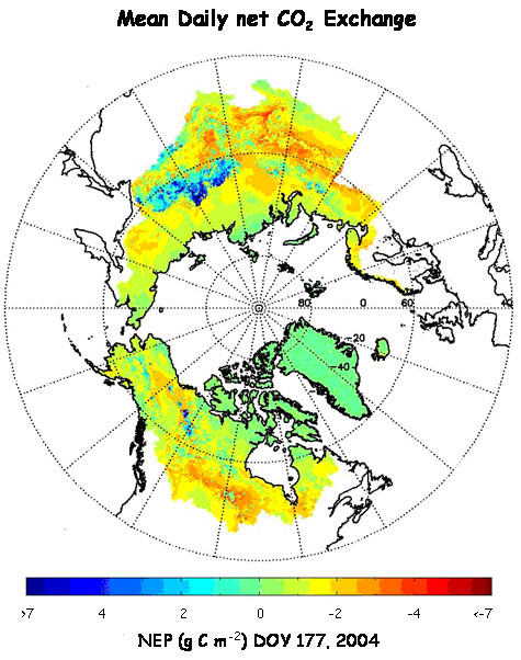 Terrestrial Carbon Flux - We are developing a new satellite-based approach for regional assessment and monitoring of terrestrial net carbon exchange (NEE) for the pan-Arctic; NEE quantifies the magnitude and direction of land-atmosphere net CO2 exchange and is a fundamental measure of the balance between carbon uptake by vegetation net primary production (NPP) and carbon loss through soil heterotrophic respiration (Rh).
Spatial Climatology
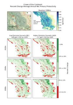 Crown of the Continent Ecosystem (CCE) - As a premiere ecosystem in North America (Hauer et al. 2007) and one of the worlds most intact temperate ecosystems (Pederson et al. 2010), the Crown of the Continent Ecosystem (CCE) straddles the Rocky Mountains from southern Alberta and British Columbia to northern Montana.
 Daymet - is a group of computer programs that produce surfaces of daily temperature, precipitation, radiation, and humidity over large regions, taking into account the effects of complex terrain.
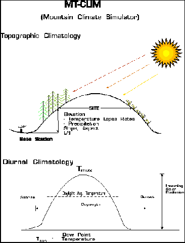 MT-CLIM - is a computer program that uses observations of daily maximum temperature, minimum temperature, and precipitation from one location (the "base") to estimate the temperature, precipitation, radiation, and humidity at another location (the "site").
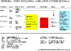 RHESSys - Regional Hydrological and Ecological Simulation System.
TopoWx - "Topography Weather" is an 800-meter resolution gridded dataset of daily minimum and maximum air temperature for the conterminous U.S. The objective of TopoWx is to provide gridded temperature estimates that accurately capture both (1) locally relevant topoclimate spatial patterns; and (2) regional climate variability and trends.
Historic
 Alaska Coastal Carbon Interactions - This project is part of a larger NSF initiative called the Study of the Northern Alaska Coastal System (SNACS). Most regional observation networks indicate that dramatic changes have occurred across the Arctic in recent decades, but comparatively little work has been done to assess atmospheric and oceanic responses to the dramatic observed terrestrial changes. Both increases in surface air temperature and a shift in arctic air circulation patterns are likely to contribute to changes in ice distribution.
Arctic Biocomplexity - This project is examining how biological and physical processes interact to control carbon uptake, storage and release in Arctic tundra ecosystems and how the self-organizing nature of these interactions varies across multiple spatial and temporal scales. Approximately 25% of the worlds soil organic carbon reservoir is stored at high northern latitudes in permafrost and seasonally-thawed soils in the Arctic, a region that is currently undergoing unprecedented warming and drying, as well as dramatic changes in human land use.
Hydrologic Change over the Pan-Arctic Basin - The geography and dynamics of water across this pan-Arctic region are important elements of the larger Earth System especially given growing evidence of the vulnerability of the Arctic climate and terrestrial biosphere to global change. The scope of this multidisciplinary project is develop online, near-real time capabilities for rapid assessment and monitoring pan- Arctic water budgets and river discharge to the Arctic Ocean.
Rangeland Productivity - Until recently, the Advanced Very High Resolution Radiometer (AVHRR) was the only broad scale, globally applicable satellite that provided direct spectral data suited for continual monitoring of vegetation. As such, many studies have successfully used AVHRR normalized difference vegetation index (NDVI) to infer photosynthetic monitor growing season phenology and estimate vegetation. On 18 December, 1999 the first Moderate Resolution Imaging Spectroradiometer (MODIS) was launched on the Terra platform of the Earth Observing System (EOS).
Remote Sensing of Lake Water Quality - Flathead Lake, located in northwest Montana, is one of the 300 largest natural freshwater lakes in the world, covering an area of 480 km2 with a maximum depth of 113 m. The Lake is oligotrophic, yet experienced an increase in eutrophication from 1977 to 2001, and two lakewide blooms of macroalgae in 1984 and 1994 that represented anomalous declines in water quality likely due to increasing nutrient inputs from anthropogenic sources.
Remote Sensing of Land Water Mobility - The lack of available water constrains hydrologic and ecological processes for two-thirds of the Earths land surface. We are working with colleagues at the NASA Jet Propulsion Laboratory to develop new satellite microwave remote sensing algorithms for detecting and monitoring land-atmosphere water and energy exchange over North America.
Urban NPP - In the process of urbanization, land formerly occupied by crops, grasslands or forest becomes permanently paved for buildings, parking lots and transportation. While urban areas have generally a lower photosyntheticcapacity than the surrounding rural environments, intensively irrigated and fertilized lawns and trees often counterbalance the decline in net primary productivity (NPP) due to the replacement of vegetated surface with constructed materials.
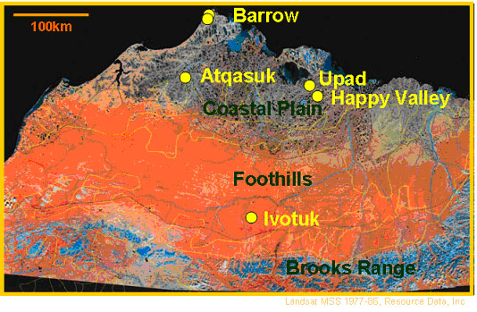
Western Arctic Linkages Experiment (WALE) - The Western Arctic Linkage Experiment (WALE) was initiated to investigate the role of northern terrestrial ecosystems in the larger Arctic system response to global change through model and satellite remote sensing analyses of regional carbon, water and energy cycles (McGuire et al. overview paper below). The NTSG portion of this investigation focused on assessing annual variability and regional trends in vegetation productivity for the WALE domain of Alaska and NW Canada, and the primary mechanisms driving observed changes over the 19-year (1982 - 2000) study period.
Wheat Yield - For decades scientists have sought to develop regionally applicable estimators of crop yield using models formulated from remote sensing data. With a few exceptions, most broad scale models, based on remote sensing, have used the Advanced Very High Resolution Radiometer (AVHRR) Normalized Difference Vegetation Index (NDVI) to derive retrospective, empirical relationships between NDVI and yield. However, while retrospective analyses provide insight into past performance, they do little to satisfy the need for near real time yield information.