
Global Evapotranspiration
Project Summary
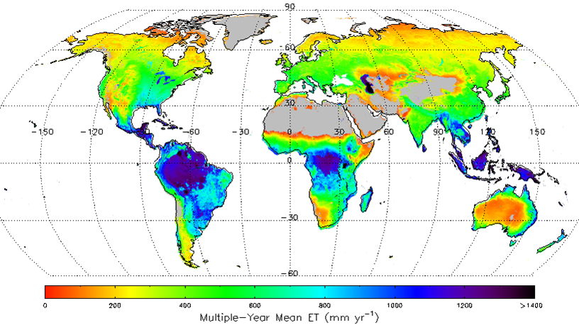
The objective of this study was to generate a global long-term (1983-2013) daily ET record with well quantified accuracy for studies on regional/global water balances changes. We applied a satellite remote sensing based evapotranspiration (ET) algorithm to assess global terrestrial ET. The algorithm quantifies canopy transpiration and soil evaporation using a modified Penman-Monteith approach with biome-specific canopy conductance determined from the NDVI, and quantifies open water evaporation using a Priestley-Taylor approach. These algorithms were applied globally using AVHRR GIMMS NDVI, NCEP/NCAR Reanalysis (NNR) daily surface meteorology and NASA/GEWEX Surface Radiation Budget (SRB) solar radiation inputs. We used observations from FLUXNET tower sites representative of the major global vegetation types to parameterize an NDVI-based canopy conductance model and then validated the global ET algorithm using measurements from additional, independent flux towers. The global ET results capture observed spatial and temporal variations at the global scale and also compare favorably (RMSE=186.3 mm yr-1; R2=0.80) with ET inferred from basin-scale water balance calculations. These data provide a relatively long term global ET record with well-quantified accuracy for assessing ET climatologies, terrestrial water and energy budgets and long-term water cycle changes.
Funding Agency:
NASA Hydrology and Earth Sustem Science Fellowship programs
Publications
Zhang, K., J.S. Kimball, R.R. Nemani, S.W. Running, Y. Hong, J.J. Gourley, and Z. Yu, 2015. Vegetation Greening and Climate Change Promote Multidecadal Rises of Global Land Evapotranspiration, Scientific Reports, 5, 15956; doi: 10.1038/srep15956.
Zhang, K., J.S. Kimball, R.R. Nemani, and S.W. Running, 2010.
A continuous satellite-derived global record of land surface evapotranspiration from 1983-2006. Water Resources Research doi:10.1029/2009WR008800.
Zhang, K., J.S. Kimball, Q. Mu, L.A. Jones, S.J. Goetz and S.W. Running, 2009.
Satellite based analysis of northern ET trends and associated changes in the regional water balance from 1983 to 2005. Journal of Hydrology 379, 92-110.