RHESSys
Project Summary
This study will determine how mountain-protected areas along a transect from western Washington to western Montana are affected by climatic variability. We will examine ecological responses to climatic variability within and between three mountain-dominated bioregions—the Olympic, North Cascades, and Northern Rocky Mountains—along a gradient from marine to continental climate. The results of this analysis will guide our efforts to identify critical indicators of ecological response to interannual and interdecadal climatic variability, identify vulnerable landscapes, and provide land managers with spatially-explicit estimates of ecosystem change.
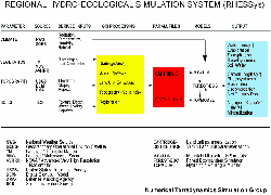
RHESSys = Regional Hydrological and Ecological Simulation System
RHESSys combines the terrestrial ecosystem process model Biome-BGC with spatially explicit meteorological information from MTCLIM or Daymet and the TOPMODEL hydrologic routing model to let us to make spatial and temporal predictions of carbon, water, and nitrogen dynamics over landscapes.
Input information derived from weather records, satellite imagery, digital terrain models, and soils maps are supplied to RHESSys via a geographic database. The computer models construct a climatic surface, and based on this and other input surfaces, simulate maps of various ecosystem properties including snowpack, soil moisture, streamflow, evaporation, and photosynthesis.
RHESSys is an important tool in understanding the effects of anthropogenic impacts on landscape-level processes. RHESSys is being implemented in a number of other lab projects to assess the impacts of land use and disturbances on stream hydrology and forest productivity.
Validation: CLIMET
Climatic Variability. Exosystem Dynamics, and Disturbance in Mountain Protected Areas:
Assessing the Vulnerability of Natural Resources through implementation of a Regional Hyrdo-Ecological Sumlation System (RHESSys)
Multiscale Analisys of Ecosystem Responses
We will determine the effects of climatic variability on mountain protected areas in the Olympic, N. Cascades, and N. Rocky Mountains bioregions across the northwestern continental U.S., encompassing a range of climates and ecosystems along altitudinal and longitudinal gradients. Multiscale analysis will be a distinctive feature of our research program, with spatial scale varying from the watershed to regional level. The study will utilize the multi-scale ecosystem analysis developed over the past two decades. The Regional Hydro-Ecological Simulation System (RHESSys,) has been developed and validated by our research team at the University of Montana/Numerical Terradynamic Simulation Group). The system provides a mechanistic basis for integrating empirical data and extrapolating across spatial scales. The MT-CLIM and TOPMODEL components of RHESSys translate daily climatic and topographic inputs to biologically relevant variables (e.g., solar radiation, soil moisture) for use in FOREST-BGC (Waring and Running 1998). FOREST-BGC then simulates water, carbon, and nitrogen cycling within forest ecosystems at the stand scale. FOREST-BGC outputs are used by a compatible modeling system (BIOME-BGC) to simulate ecosystem dynamics at large (regional) spatial scales. These models have been used to provide input to resource management decision making (White et al. 1998), as well as for scientific analysis, and will allow us to compare mountain systems across environmental gradients and provide a regional synthesis.
Study Areas
The study area has a gradient of climatic types, controlled by dominant air masses, ranging from maritime (Olympic) to transitional (N. Cascades) to continental (N. Rockies). Winter temperatures are moderate in the Olympics, intermediate in the N. Cascades, and cold in the N. Rockies. Summer precipitation as a proportion of annual is greater in the N. Rockies than in the other bioregions. Precipitation varies dramatically between westside and eastside locations within each bioregion. For example, precipitation in the Olympic Bioregion ranges from >600 cm/yr on Mt. Olympus to only 40 cm/year in the northeastern rainshadow; precipitation in the N. Rockies varies from 350 cm/yr (westside, high elevation) to 30 cm/yr (eastside, low elevation). This contrast in precipitation over relatively small distances has a profound impact on microclimate, vegetation distribution, and disturbance regimes.
Image: