
Hydro-Economics of Agricultural Regions
Project Summary:
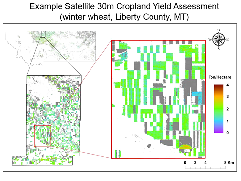
The role of NTSG in this project is to develop new satellite based capabilities for mapping and monitoring of field level cropland productivity and water use changes, including evapotranspiration and agricultural yields, for the major Montana crop types and agricultural regions. Our approach leverages information from global operational NASA satellites, which allows us to extend our observation and model framework over multiple years and larger domains, including the continental USA and other major agricultural regions.
Images:
Selected Publications:
Guan, K., J. Wu, J.S. Kimball, M.C. Anderson, S. Frolking, B. Li, C.R. Hain, and D. Lobell, 2017. The shared and unique values of optical, fluorescence, thermal and microwave satellite data for estimating large-scale crop yields. Remote Sensing of Environment, 199, 333-349.
He, M., J.S. Kimball, M. Maneta, B. Maxwell, A. Moreno, S. Begueria, and X. Wu, 2018. Regional crop gross primary productivity and yield estimation using fused Landsat-MODIS data. Remote Sensing, 10, 372.
Robinson, N.P., B.W. Allred, M.O. Jones, A. Moreno, J.S. Kimball, D.E. Naugle, T.A. Erickson, and A.D. Richardson, 2017. A dynamic Landsat derived normalized difference vegetation index (NDVI) product for the conterminous United States. Remote Sensing 9, 863
Key project links and data:
NTSG Personnel:
John Kimball (co-PI)