
Satellite Global Flood Monitor
Project Summary
 Better capabilities are needed for global monitoring of surface water inundation dynamics to improve early-warning detection, tracking, and mitigation of flood-related hazards. Many polar-orbiting and geostationary environmental satellites provide global coverage and frequent observations from optical and near-infrared sensors that are suitable for flood mapping; although capabilities from these sensors are degraded over many areas due to clouds and atmospheric aerosol contamination, or low light levels. However, satellite retrievals from lower frequency microwave sensors can detect changes in surface water inundation extent day-or-night and in nearly all-weather conditions.
We developed a new capability for global flood monitoring using L-band (1.4 GHz) microwave brightness temperature (Tb) observations from the NASA SMAP (Soil Moisture Active Passive) mission. We exploit the strong L-band microwave sensitivity to surface water to retrieve the spatial fraction of water (fw) inundation within the satellite footprint. The SMAP fw retrievals are corrected for potential soil moisture and vegetation contributions to the microwave signal using complimentary higher frequency Tb observations from AMSR2 (Advanced Microwave Scanning Radiometer 2). The resulting fw record provides global coverage and 1-3 day repeat observations posted to a consistent 36-km resolution global grid. The fw retrievals are strongly sensitive to surface water cover variations within the relatively coarse (~40km) SMAP sensor footprint, and are well suited for global monitoring of dynamic flood events. To enable finer scale (30m resolution) flood assessments, the SMAP fw retrievals are dynamically downscaled using ancillary water occurrence metrics derived from a long-term Landsat observational record. Continuing SMAP and AMSR2 operations enable near real-time, multi-scale monitoring of global surface water inundation trends and flood-related impacts. These results provide new capacity for flood monitoring from synergistic satellite observations that are particularly valuable for data sparse regions.
Example Images
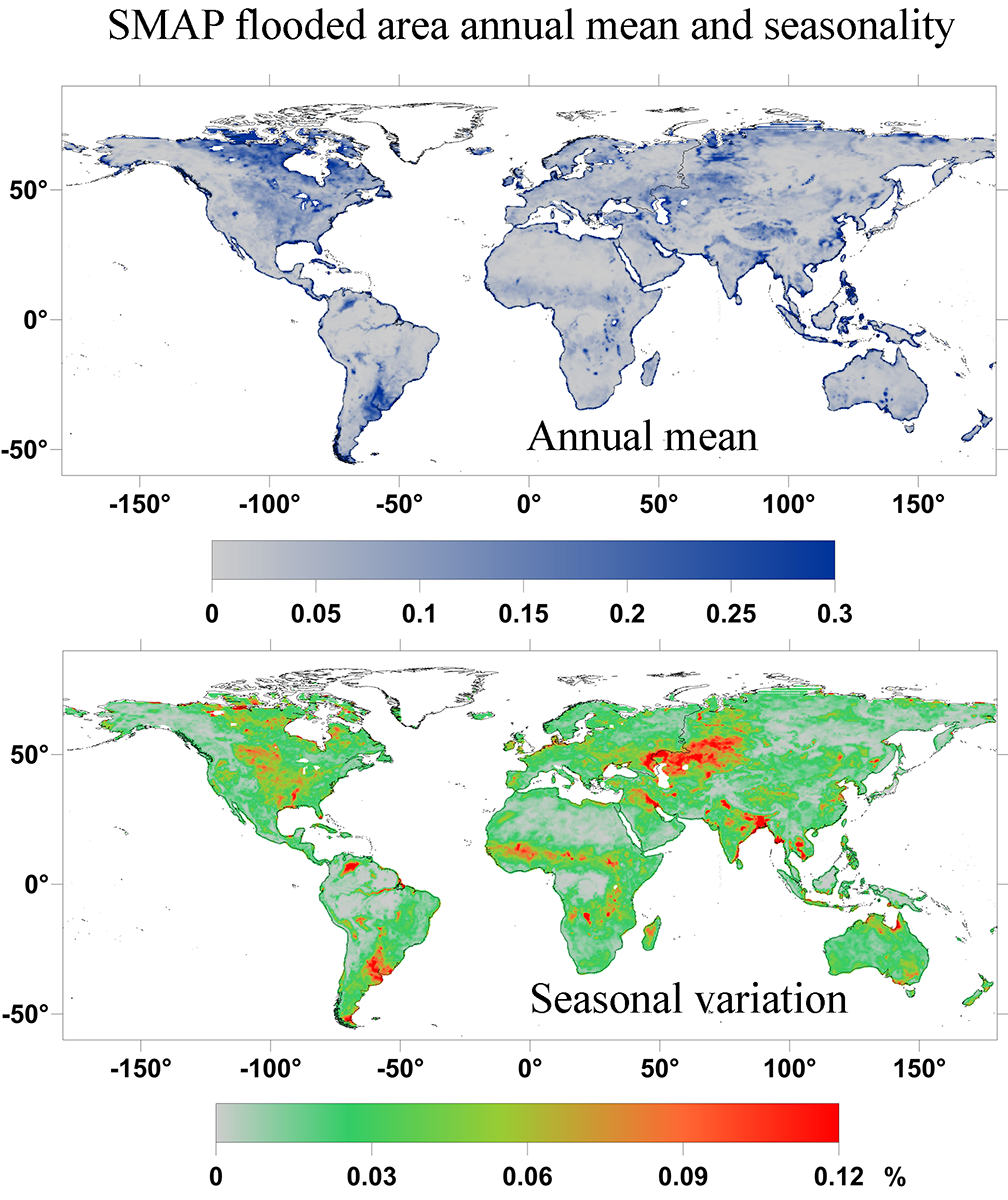
SMAP flooded area annual mean and seasonality
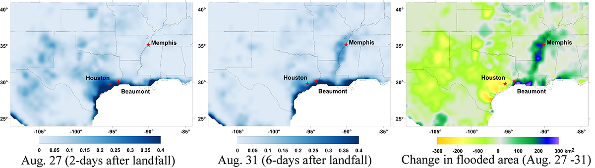
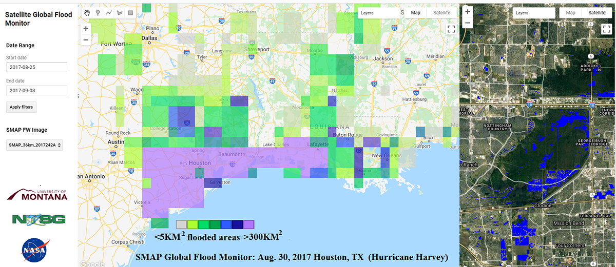
SMAP Satelite Monitoring of Flood Area Changes from Hurricane Harvey
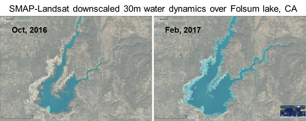
SMAP-Landsat donwnscaled 30m water dynamics over Folsum lake, CA
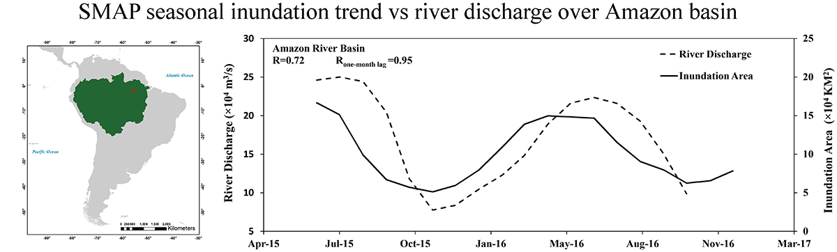
SMAP seasonal induction trend vs river discharge over Amazon basin
Selected Publications
Du, J., J.S. Kimball, J. Sheffield, M. Pan, C.K. Fisher, H.E. Beck, E.F. Wood, 2021. Satellite flood inundation assessment and forecast using SMAP and Landsat. IEEE Journal of Selected Topics in Applied Earth Observations and Remote Sensing, doi: 10.1109/JSTARS.2021.3092340.
Du, J., J.S. Kimball, J. Galantowicz, S.-B. Kim, S.K. Chan, R. Reichle, L.A. Jones, and J.D. Watts. 2018. Assessing global surface water inundation dynamics using combined satellite information from SMAP, AMSR2 and Landsat. Remote Sensing of Environment, 213, doi:10.1016/j.rse.2018.04.054.
Du, J., J.S. Kimball, L.A. Jones, Y. Kim, J. Glassy, and J.D. Watts, 2017. A global satellite environmental data record derived from AMSR-E and AMSR2 microwave earth observations, 2017. Earth System Science Data, 9, 791-808, https://doi.org/10.5194/essd-9-791-2017.
Wu, H., J.S. Kimball, N. Zhou, L. Alfieri, L. Luo, J. Du, and Z. Huang, 2019. Evaluation of real-time global flood modeling with satellite surface inundation observations from SMAP. Remote Sensing of Environment, 233, 111360.Key Datasets
Global Flood Monitor Webtool (Google Earth Engine APP):
https://jinyangdu.users.earthengine.app/view/smapglobalfloodmonitor
SMAP fw global data record available from NTSG archives:
http://files.ntsg.umt.edu/data/SMAP_FW/SMAP_FW_36KM/
AMSR Global Land Parameter Data Record distributed by NASA NSIDC DAAC:
https://nsidc.org/data/nsidc-0451NTSG Personnel
Jinyang Du
John Kimball
Collaborators
Justin Sheffield (Univ. Southampton, UK)
Ming Pan (UCSD), Eric Wood (Princeton Univ.)
Huan Wu (UMD)