
The NASA Soil Moisture Active Passive (SMAP) mission
Project Summary
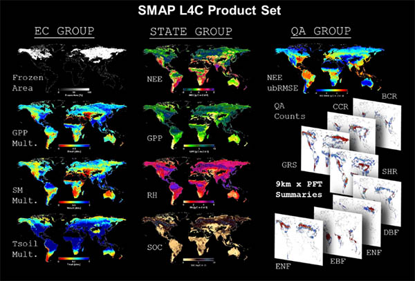
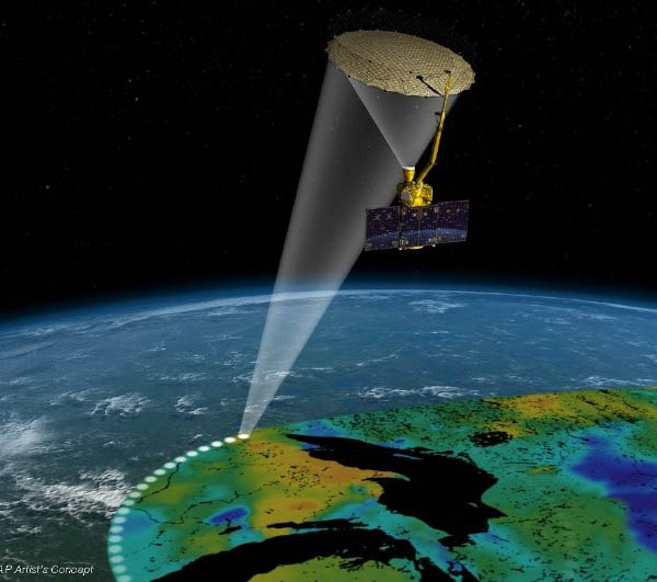
The Soil Moisture Active Passive (SMAP) mission is a first-tier NASA Decadal Survey mission successfully launched in January 2015. The SMAP satellite consists of L-band radar and radiometer sensors designed for global mapping and monitoring of soil moisture and landscape freeze/thaw dynamics. Primary science objectives for the mission include: improving understanding of processes linking terrestrial water, energy and carbon cycles; quantifying the net carbon flux in boreal ecosystems and reducing uncertainties regarding the purported missing carbon sink on land. NTSG is partnering with NASA to produce global operational land products and science applications for SMAP that address mission water and carbon science objectives. These products include SMAP Level 3 retrievals of daily landscape freeze-thaw status and a model enhanced Level 4 Carbon (L4C) product. The SMAP L4C product provides consistent global daily estimates of the terrestrial carbon budget with refined accuracy and performance suitable for global change assessment and monitoring. The L4C product is publicly distributed and includes daily quantification of net ecosystem carbon (CO2) exchange, vegetation photosynthesis (GPP) and ecosystem respiration, surface soil organic carbon and underlying environmental controls on these processes, including soil moisture and frozen temperature constraints.
Images
Selected Publications
Derksen, C., X. Xu, R.S. Dunbar, A. Colliander, et al., 2017. Retrieving landscape freeze/thaw state from Soil Moisture Active Passive (SMAP) radar and radiometer measurements. Remote Sensing of Environment 194, 48-62.
Du, J., J.S. Kimball, J. Galantowicz, S.-B. Kim, S.K. Chan, R. Reichle, L.A. Jones, and J.D. Watts. 2018. Assessing global surface water inundation dynamics using combined satellite information from SMAP, AMSR2 and Landsat. Remote Sensing of Environment, 213, doi:10.1016/j.rse.2018.04.054.
Jones, L.A., J.S. Kimball, R.H. Reichle, N. Madani, J. Glassy, J.V. Ardizzone, A. Colliander, J. Cleverly, A.R. Desai, D. Eamus, E.S. Euskirchen, L. Hutley, C. Macfarlane, and R.L. Scott, 2017. The SMAP Level 4 Carbon product for monitoring ecosystem land-atmosphere CO2 exchange. IEEE TGARS, 55, 11, 6517-6532, doi:10.1109/TGRS.2017.2729343.
Satellite monitoring of global surface soil organic carbon dynamics using the SMAP Level 4 Carbon product.
Citation
Endsley, K.A., J.S. Kimball, R.H. Reichle, J.D. Watts. 2020. Satellite monitoring of global surface soil organic carbon dynamics using the SMAP Level 4 Carbon product. Journal of Geophysical Research: Biogeosciences 125(12). https://agupubs.onlinelibrary.wiley.com/doi/abs/10.1029/2020JG006100
Abstract
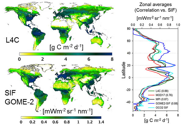
Soil organic carbon (SOC) is an important metric of soil health and the terrestrial carbon balance. Short‐term climate variations affect SOC through changes in temperature and moisture, which control vegetation growth and soil decomposition. We evaluated a satellite data‐driven carbon model, operating under the NASA Soil Moisture Active‐Passive (SMAP) mission, as a means of monitoring global surface SOC dynamics. The SMAP Level 4 Carbon (L4C) product estimates a daily global carbon budget including surface (0‐ to 5‐cm depth) SOC. We found that the L4C mean latitudinal SOC distribution is generally consistent with alternative assessments from static soil inventory records and dynamic global vegetation models (r ≥ 0.89). Within forest systems, based on inventory data, L4C SOC is most similar in magnitude to litterfall but is correlated with coarse woody debris and total SOC. L4C SOC is sensitive to seasonal and annual climate variability, with mean residence times that range from 1.5 years in the wet tropics to 17 years in the cold tundra. Incorporating soil moisture retrievals from the SMAP L‐band (1.4 GHz) microwave radiometer within the L4C algorithm provides enhanced soil moisture sensitivity under low‐to‐moderate vegetation cover (<5 kg m−2 vegetation water content). The L‐band soil moisture had the greatest impact on the L4C carbon budget in semiarid regions, which span almost 60% of the globe and account for substantial variability in the terrestrial carbon sink. The L4C operational product enables prognostic investigations into effects of recent climate trends and anomalies (e.g., droughts and pluvials) on shallow soil carbon dynamics.
Monitoring crop status in the Continental United States using the SMAP Level 4 Carbon product.
Citation
Wurster, P., M.P. Maneta, J.S. Kimball, K.A. Endsley, S. Beguería. 2020. Monitoring crop status in the Continental United States using the SMAP Level 4 Carbon product. Frontiers in Big Data. https://www.frontiersin.org/articles/10.3389/fdata.2020.597720/abstract
Abstract
Accurate monitoring of crop condition is critical to detect anomalies that may threaten the economic viability of agriculture and to understand how crops respond to climatic variability. Retrievals of soil moisture and vegetation information from satellite-based remote-sensing products offer an opportunity for continuous and affordable crop condition monitoring. This study compared weekly anomalies in accumulated gross primary production (GPP) from the SMAP Level-4 Carbon (L4C) product to anomalies calculated from a state-scale weekly crop condition index (CCI) and also to crop yield anomalies calculated from county-level yield data reported at the end of the season. We focused on barley, spring wheat, corn, and soybeans cultivated in the continental United States from 2000 to 2018. We found that consistencies between SMAP L4C GPP anomalies and both crop condition and yield anomalies increased as crops developed from the emergence stage (r: 0.4–0.7) and matured (r: 0.6–0.9) and that the agreement was better in drier regions (r: 0.4–0.9) than in wetter regions (r: −0.8–0.4). The L4C provides weekly GPP estimates at a 1-km scale, permitting the evaluation and tracking of anomalies in crop status at higher spatial detail than metrics based on the state-level CCI or county-level crop yields. We demonstrate that the L4C GPP product can be used operationally to monitor crop condition with the potential to become an important tool to inform decision-making and research.
NTSG Personnel:
John Kimball (PI), Lucas Jones, Tobias Kundig, Youngwook Kim, Nima Madani