
Lake Ice Phenology
Project Summary:
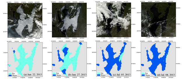
Effective methods for regional lake ice monitoring are needed for northern ecosystem and infrastructure assessments. We developed an automated method for satellite assessment of seasonal lake ice phenology using 36.5 GHz, H-polarized brightness temperature (Tb) observations from the Advanced Microwave Scanning Radiometer (AMSR-E/2) sensors. Unlike satellite optical-IR sensors, our method exploits enhanced microwave sensitivity to lake water-ice transitions, with minimal atmosphere cloud-aerosol and illumination constraints. The resulting geospatial lake ice record provides relatively precise mapping of ice cover variations for >900 lakes (76,671 lake pixels) from 2002-2015. A Moving t-Test (MTT) algorithm allows for automated lake ice retrievals (ice-on/off) with daily temporal fidelity and 5-km gridding for all lake pixels (water coverage ≥ 50%) in the Northern Hemisphere. The resulting lake phenology metrics include seasonal timing and duration of annual ice cover, which were found to be consistent with other available ground and satellite observations. The ice phenology record provides suitable accuracy for science applications that require timely monitoring of lake ice events, including global change assessments, ecosystem studies, and weather predictions.
Science Team
Jinyang Du
John Kimball
Youngwook Kim
Jennifer Watts
Publications
Du, J, J.S. Kimball, C. Duguay, Y. Kim and J.D. Watts, 2017.
Satellite microwave assessment of Northern Hemisphere lake ice phenology from 2002 to 2015. The Cryosphere, 11, 47-63.
Key Datasets
Lake ice data access through NTSG
Lake ice data access through NSIDC