
Daymet
Project Summary
Meteorology at the land surface affects many processes in the terrestrial biogeochemical system. Measurements of near-surface meteorological conditions are made at many locations, but we are often faced with having to perform ecosystem process simulations in areas where no meteorological measurements have been taken. In some cases it is possible to install new instrumentation for a particular study, but there are many situations where this is not a feasible solution. These problems are particularly important for simulations over large regions, where the number of simulation points is likely to be far greater than the number of observation stations. Starting from the MT-CLIM logic, we developed a set of algorithms to interpolate daily weather observations between observation locations, and to extrapolate from low elevations (where measurements are commonly made) to higher elevations.
1980-2016 DAYMET Dataset is available online
Details
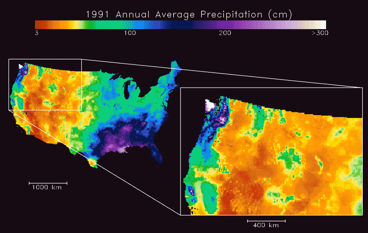
Daymet is a group of computer programs that produce surfaces of daily temperature, precipitation, radiation, and humidity over large regions, taking into account the effects of complex terrain. Observations can be included from an arbitrarily large number of stations. The relationships of temperature and precipitation to elevation are determined directly from the observations. In addition to the daily observations from a network of stations, Daymet requires digital elevation data for the region of interest.
The interpolation method is based on the spatial convolution of a truncated Gaussian weighting filter with the set of station locations. Sensitivity to the typical heterogeneous distribution of stations is accomplished with an iterative station density estimation algorithm.
The extrapolation with elevation depends on the station observations and the station elevations. These relationships vary in space and time, and Daymet makes a new diagnosis of these relationships for each spatial modeling unit and for each day of observed conditions.
Precipitation estimates are performed in two steps: first a binary estimate of precipitation occurrence, and contingent on occurrence, an estimation of precipitation amount, corrected for elevation effects.
Radiation and humidity are estimated using the same relationships as in the MT-CLIM model, following the completion of temperature and precipitation estimates.
Images
NTSG Personnel
Publications
Bristow, K.L., and G.S. Campbell, 1984. On the relationship between incoming solar radiation and daily maximum and minimum temperature. Agricultural and Forest Meteorology, 31:159-166.
Running, S.W., R.R. Nemani, and R.D. Hungerford, 1987. Extrapolation of synoptic meteorological data in mountainous terrain and its use for simulating forest evaporation and photosynthesis. Canadian Journal of Forest Research, 17:472-483.
Glassy, J.M., and S.W. Running, 1994. Validating diurnal climatology of the MT-CLIM model across a climatic gradient in Oregon. Ecological Applications, 4(2):248-257.
Kimball, J.S., S.W. Running, and R. Nemani, 1997. An improved method for estimating surface humidity from daily minimum temperature. Agricultural and Forest Meteorology, 85:87-98.
Thornton, P.E., S.W. Running, and M.A. White, 1997. Generating surfaces of daily meteorological variables over large regions of complex terrain. Journal of Hydrology, 190:214-251.
Thornton, P.E., and S.W. Running, 1999. An improved algorithm for estimating incident daily solar radiation from measurements of temperature, humidity, and precipitation. Agricultural and Forest Meteorology, 93:211-228.